Title: anamorphosis maps
Post by: scarface on March 31, 2013, 12:27 PM
Post by: scarface on March 31, 2013, 12:27 PM
I've found a fews map showing countries with their population proportional to the urban areas.
These maps are called "population cartograms".
For Egypt you can barely recognize the country.


These maps are called "population cartograms".
For Egypt you can barely recognize the country.
Title: Re: anamorphosis maps
Post by: scarface on June 20, 2014, 12:33 AM
Post by: scarface on June 20, 2014, 12:33 AM
I hope you have found these maps interesting.
But I find this topic is a little empty.
I wanted to add maps of density, it's always interesting to see we are in a world where the population is very unevenly distributed.
I also searched some statistics related to gdp. For Europe it's quite easy but I tried to find some statistics about Egypt for example, to no avail, probably because I don't know the names of the local statistics institutes.
For example, for France, here is a chart listing the departments with their global gdp, and their gdp per capita: http://www.insee.fr/fr/themes/tableau.asp?reg_id=99&ref_id=t_2601D
I'd like to find similar charts for other countries (in English, preferably).
Title: Re: anamorphosis maps
Post by: scarface on June 20, 2014, 07:26 PM
Post by: scarface on June 20, 2014, 07:26 PM
I'm going to put a few maps of density. Some people might discover their own country differently.
Let's begin with Palestine.
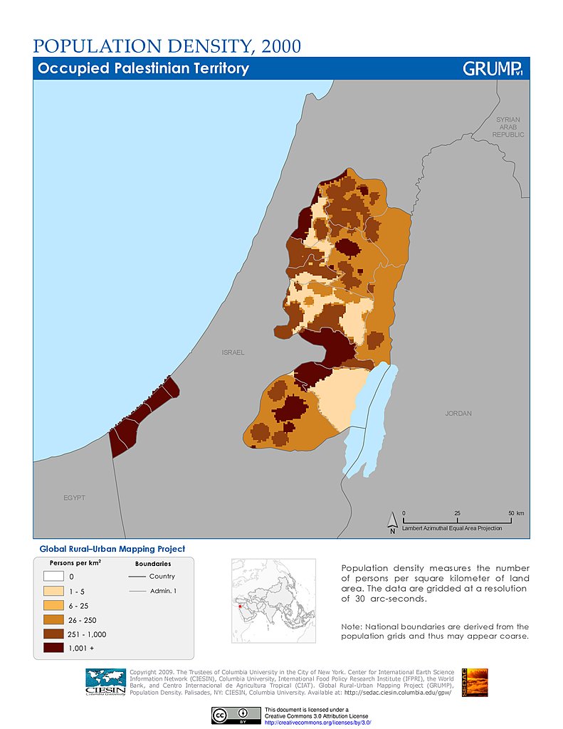
On this map, we can realize that the Gaza territory and the west of the West Bank are very populated whereas the region around the dead sea is mostly desert and uninhabited.
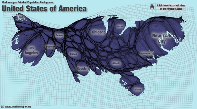
The USA:
For humbert, and for anyone who knows the US, this map has no secret.

We can see that the population is very dense in the North East, in the big lakes region, on the East of Florida, and on the West coast (with LA and SF). The inner country is more sparsely populated and mostly desert in the west, except Texas. Anyway, the US is a fragile country, because the population is essentially urban, only 2 or 3% of the population are working in the agricultural sector to feed the remaining 97%, and this organization requires a lot of oil to transport the food in the towns.
My window is closed but I heard some shouts in the street. France has scored vs Switzerland...
Let's begin with Palestine.
On this map, we can realize that the Gaza territory and the west of the West Bank are very populated whereas the region around the dead sea is mostly desert and uninhabited.
The USA:
For humbert, and for anyone who knows the US, this map has no secret.
We can see that the population is very dense in the North East, in the big lakes region, on the East of Florida, and on the West coast (with LA and SF). The inner country is more sparsely populated and mostly desert in the west, except Texas. Anyway, the US is a fragile country, because the population is essentially urban, only 2 or 3% of the population are working in the agricultural sector to feed the remaining 97%, and this organization requires a lot of oil to transport the food in the towns.
My window is closed but I heard some shouts in the street. France has scored vs Switzerland...
Title: Re: anamorphosis maps
Post by: humbert on June 21, 2014, 04:55 AM
Post by: humbert on June 21, 2014, 04:55 AM
The data is 10 years old but I'd say it's pretty accurate.
I disagree with your assessment of the country being vulnerable. That 3% you mentioned produces massive amounts of food, enough for the domestic population with plenty left over for export. I've traveled to northern Missouri and, believe me, wheat and corn fields are so huge it's like the ocean -- you can't see where the field ends. The oligarchy that rules this country know perfectly that if they're to stay in power, food must remain cheap and plentiful.
I disagree with your assessment of the country being vulnerable. That 3% you mentioned produces massive amounts of food, enough for the domestic population with plenty left over for export. I've traveled to northern Missouri and, believe me, wheat and corn fields are so huge it's like the ocean -- you can't see where the field ends. The oligarchy that rules this country know perfectly that if they're to stay in power, food must remain cheap and plentiful.
Title: Re: anamorphosis maps
Post by: scarface on June 21, 2014, 08:49 AM
Post by: scarface on June 21, 2014, 08:49 AM
The US is producing a lot of food with a mecanized agriculture, right. But the people dont live where the food is produced, Las Vegas is a good exemple, as it's a town in a desert. With an expensive oil, or without oil, the people will have the choice between starving or moving to the countryside. It's the same thing in a lot of countries. This problem has been dealt in the survivalist topic anyway. In the meantime there are american soldiers in Irak and in the middle East to monitor the pipelines, there is nothing to worry about.
Title: Re: anamorphosis maps
Post by: scarface on June 21, 2014, 09:56 AM
Post by: scarface on June 21, 2014, 09:56 AM
Here is a map for Indonesia. iih might recognize his country.
We can see that the island of Java, with the capital Jakarta, is extremly populated (it's the most populated island in the world with 130 million people), while the island of kalimantan is nearly desert.
Few people know it, but Indonesia is the most populated muslim country in the world.

We can see that the island of Java, with the capital Jakarta, is extremly populated (it's the most populated island in the world with 130 million people), while the island of kalimantan is nearly desert.
Few people know it, but Indonesia is the most populated muslim country in the world.
Title: Re: anamorphosis maps
Post by: scarface on June 21, 2014, 07:32 PM
Post by: scarface on June 21, 2014, 07:32 PM
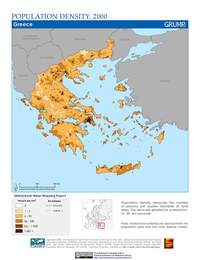
Here is a map of density for Greece. Im sure harkaz knows well this map. Im still wondering where he's leaving, I had inspected his ip and found he was in Crete but Im not sure.
We can see that the province of Attica and Crete are densely populated, while the mountains in the north are mostly desert.
Tonight I met my godfather and his daughter who has become a real goddess. On the way back, the subway was steeming with people. It's another symptom of overpopulation.
http://i.imgur.com/FM7sGtA.jpg
to gujjar: China has adopted a strict policy and the fertility rate has plunged unlike most muslim countries where there is no policy and perhaps no awereness amongst the population. Ask yourself how so many people are going to eat, have a job and a decent life if their countries is overpopulated. The food eaten by the neighbour is the food you dont have in your plate...unless you eat the neighbour!
Recenty, Ive read statistics about Saudi Arabia. 30 years ago, the average woman had 8 children.
Today, it's 3. It's also due to phisical factors, feeding 8 children today is nearly impossible except for the rich perhaps. But it's still too much. If we do a small calculation, (Ahmad knows I'm good at math), we understand that it involves an increase in the population by 50% for each generation. In the survivalist topic, I had posted a chart showing the predicament of the reindeer of the st matthew Island. In the nature, when a phenomenon is exponential, it's not long lasting.
Title: Re: anamorphosis maps
Post by: scarface on July 06, 2014, 02:32 PM
Post by: scarface on July 06, 2014, 02:32 PM
Here we can see a map for the population density of Bangladesh, the black areas being the most densely populated areas, but in fact even the orange color areas are densely populated (more than 700 inhabitants per km²), it's a question of relativity

This country is extremely populated and today there are 160 million people in Bangladesh on a small territory. If we take an example, if the US was populated like Bangladesh, there would be 10 billion people in the US. Of course, such a population is a wealth for this country, but it involves housing problems, poverty, fast rate of urbanization and environmental issues.
In the coming years, the situation could become even more precarious for Bangladesh as there is still a rapid increase in the population.
Here we can see a train in a station in Dacca, the capital of the country, an agglomeration of 15 million people, which makes it the 9th agglomeration in the world.
Title: Re: anamorphosis maps
Post by: humbert on July 08, 2014, 02:09 AM
Post by: humbert on July 08, 2014, 02:09 AM
As is always the case, populations are self-stabilizing. Once there are no resources to feed and meet the needs of all those people, the population automatically drops to a sustainable level. This happens in all species.
gujjar -> do you know if this business of ±8 children per married woman is because birth control is not permitted, or is that that these rich shieks have all those kids because they can afford them? Believe me, children are very costly.
gujjar -> do you know if this business of ±8 children per married woman is because birth control is not permitted, or is that that these rich shieks have all those kids because they can afford them? Believe me, children are very costly.
Title: Re: anamorphosis maps
Post by: scarface on July 15, 2014, 01:29 AM
Post by: scarface on July 15, 2014, 01:29 AM
Tonight I'm going to talk about Japan. Perhaps some of you don't know this country very well. This country, situated in Asia is very populated, and it's one of the richest countries in the world. But like countries of Europe, its population is more and more old, and it's suffering serious problems of debt. And it's important to understand that this country has no commodities, Japan has to import oil, coal, and electricity since the accident of fukushima. That's why the government has been obliged to print a lot of money not to go bankrupt. As a consequence, the yen has lost nearly 50% (vs $) since 2012 and therefore the price of oil has soared. I already talked about that in this post: http://www.nomaher.com/forum/index.php?topic=1028.msg12310#msg12310
Nevertheless, the richest region of the world, even if we have seen that the economy of Japan is not buoyant, is the region of kanto, which includes Tokyo, the biggest agglomeration of the world.
This map shows the gdp of each regions of Japan and compare them to other countries.

Shinjuku, the business area of Tokyo

Nevertheless, the richest region of the world, even if we have seen that the economy of Japan is not buoyant, is the region of kanto, which includes Tokyo, the biggest agglomeration of the world.
This map shows the gdp of each regions of Japan and compare them to other countries.
Shinjuku, the business area of Tokyo
Title: Re: anamorphosis maps
Post by: humbert on July 15, 2014, 02:57 AM
Post by: humbert on July 15, 2014, 02:57 AM
You've got to admire the people of Japan. 100 million people living on 4 volcanic islands with almost no natural resources, and yet they managed to form a massive empire. Despite being the only people on this planet who were ever nuked, the country not only survived but managed to become an economic power not even 20 years after Hiroshima and Nagasaki. Imagine those people in a country such as [for example] Colombia, which is full of natural resources. They'd take over the world.
As for Japan's population getting old, I'm surprised you'd see that as something bad given that this mean the birth rate is declining, which will inevitably drop the population. I always hear you complain of huge population densities elsewhere.
Sometimes I think you're like the typical woman complainer: when you put it in, she screams, but when you take it out, she cries. ;) ;D
Title: Re: anamorphosis maps
Post by: scarface on July 25, 2014, 12:34 AM
Post by: scarface on July 25, 2014, 12:34 AM
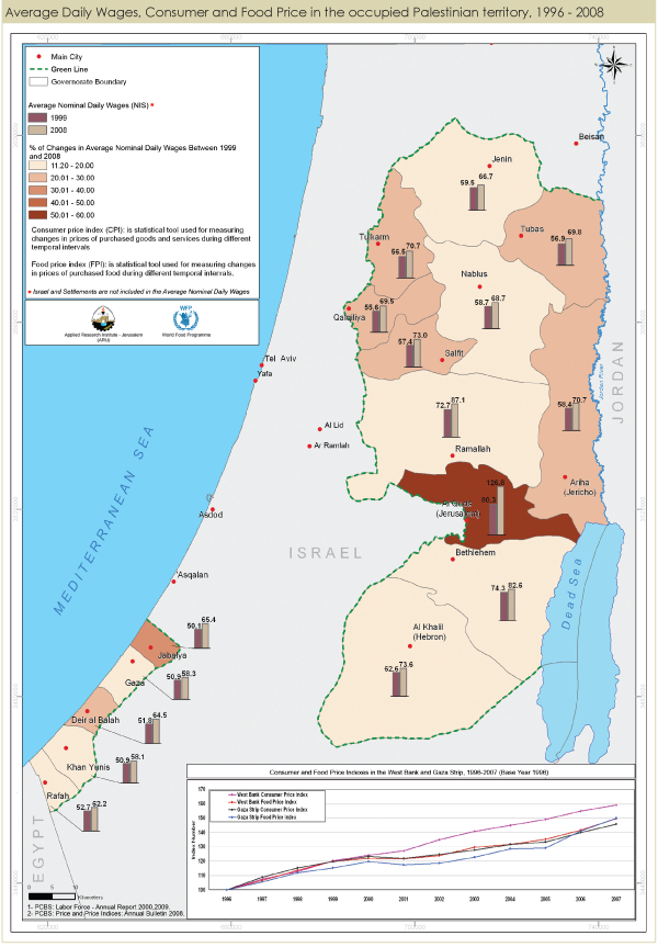
In the previous discussions, I have talked about Palestine, and I have found a map which shows the gdp per person. It's always interesting to know these figures when you are traveling, because they are usually an indicator of the level of education of the persons and of economic development.
On this map we can see that it is the region around the capital Jerusalem which is the most wealthy, ramallah being the second region, and the Gaza strip which is the poorest and this is perhaps explaining the current problems.. Anyway this map is probably outdated because the recent figures I found show a very big gap between west bank and Gaza.
For Europe you have this map, and it's usually correlated with the level of education of people.
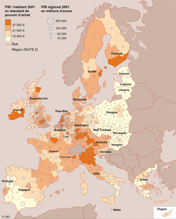
If you don't speak spanish or polish, don't go to Spain or to Poland, they won't understand you (perhaps in Barcelona, although I'm not sure)
A few years ago I had been to the south of Spain, in the town of Alicante. And I had been amazed by the dirt in the streets, and by the complete inability of the people in the streets to speak English (even though it's a beautiful town). One day I remember that I needed a stamp but I didn't know how to translate that or how to say post office. I asked that in several shops and nobody had been able to answer. When you know that it's a touristic region, it's a little worrying for these people not to understand the basics in English. On the contrary, I've met German people and they were always excellent at English. As for the English, well, unfortunately they don't care, because they already speak English. I knew a man near Norwich, and he was supposedly learning French, but he never spoke to me in French, It was more a burden for him than anything else.
On this map we can see that it is the region around the capital Jerusalem which is the most wealthy, ramallah being the second region, and the Gaza strip which is the poorest and this is perhaps explaining the current problems.. Anyway this map is probably outdated because the recent figures I found show a very big gap between west bank and Gaza.
For Europe you have this map, and it's usually correlated with the level of education of people.
If you don't speak spanish or polish, don't go to Spain or to Poland, they won't understand you (perhaps in Barcelona, although I'm not sure)
A few years ago I had been to the south of Spain, in the town of Alicante. And I had been amazed by the dirt in the streets, and by the complete inability of the people in the streets to speak English (even though it's a beautiful town). One day I remember that I needed a stamp but I didn't know how to translate that or how to say post office. I asked that in several shops and nobody had been able to answer. When you know that it's a touristic region, it's a little worrying for these people not to understand the basics in English. On the contrary, I've met German people and they were always excellent at English. As for the English, well, unfortunately they don't care, because they already speak English. I knew a man near Norwich, and he was supposedly learning French, but he never spoke to me in French, It was more a burden for him than anything else.
Title: Re: anamorphosis maps
Post by: humbert on July 26, 2014, 01:11 AM
Post by: humbert on July 26, 2014, 01:11 AM
Logic alone tells you what people who make more money or live in areas that do are much more educated than those who don't. Many poor people hardly get more than a few years of basic schooling.
Regarding Spain, have you travelled to other parts of that country? Would you say the situation is not as bad as in Alicante?
Regarding languages, there's another important factor to consider. Europe is tiny compared to nations in the Western Hemisphere and Africa. Also, just about every country uses a different language with a few exceptions, so we're talking many 25 languages in a small amount of space. Not surprisingly, many Europeans speak 3 or more. The Western Hemisphere uses only 5 European [official] languages and many more indigenous dialects which are barely even spoken. From the Rio Grande (US-Mexico border) south all the way to Cape Horn you have Spanish, Portuguese (Brazil) and the 3 other languages in the Guyanas. From the Rio Grande all the way to the North Pole you have English and French in Quebéc Province. All that territory, all those people, just those few languages - no wonder here it's so hard to find someone who speaks 3 languages.
Title: Re: anamorphosis maps
Post by: scarface on August 08, 2015, 02:15 PM
Post by: scarface on August 08, 2015, 02:15 PM
I'm adding a new gridded population cartogram generated over the whole surface of Earth. It divides the world into equal spaces of population. Today, China, India, Pakistan, Indonesia, Thailand, Vietnam, Bangladesh and Japan are together more populated than the rest of the word.
Perhaps you will be able to see your country.

The map is a bit different for tourism:
The world major tourist destination.

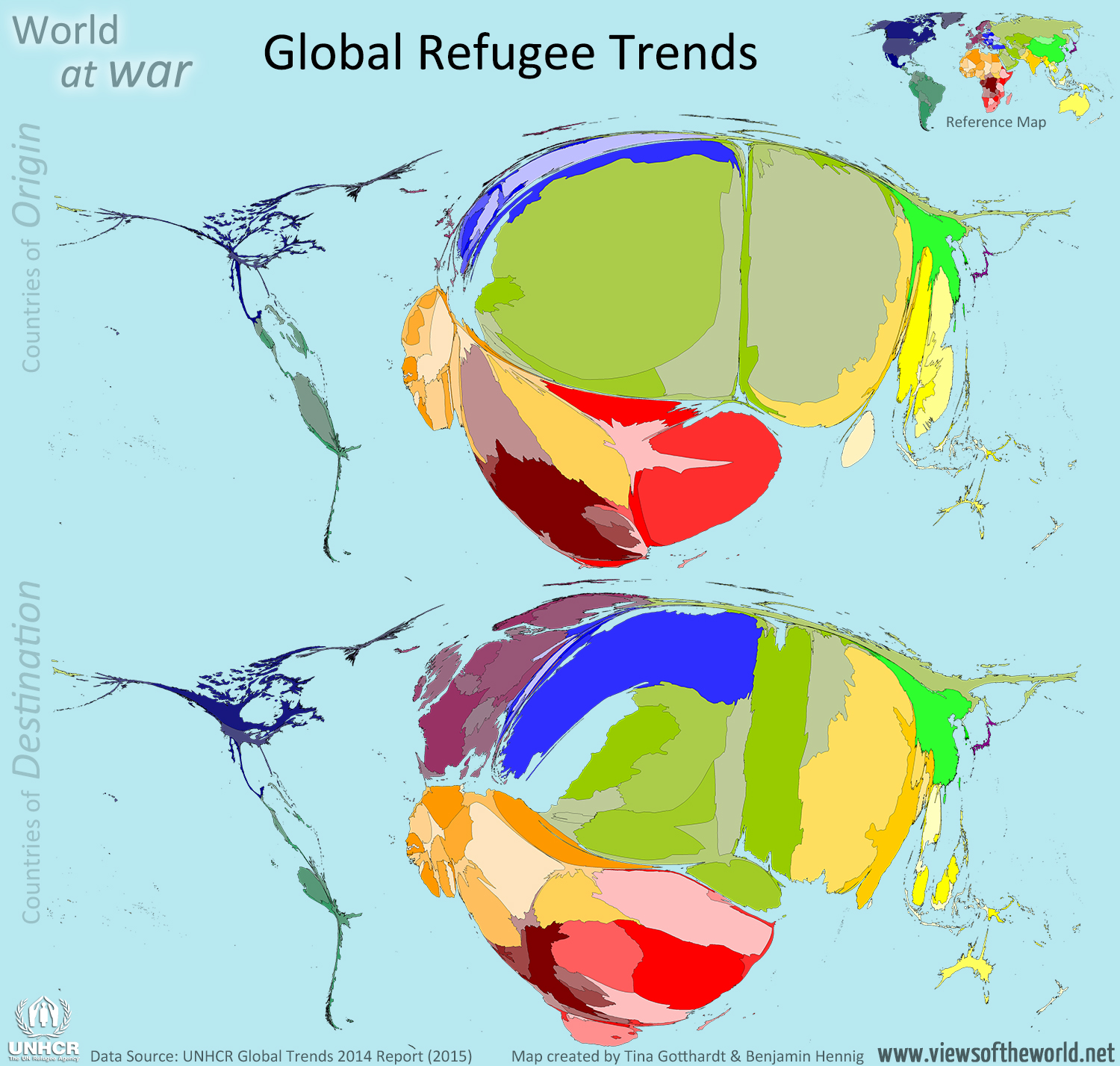
And the one of the origin of refugees...the winner being Syria
A map for life expectancy...

Perhaps you will be able to see your country.
The map is a bit different for tourism:
The world major tourist destination.
And the one of the origin of refugees...the winner being Syria
A map for life expectancy...
Title: Re: anamorphosis maps
Post by: scarface on August 30, 2015, 08:56 PM
Post by: scarface on August 30, 2015, 08:56 PM
In this new message, you will find a few recent population density maps.
The United States:

Central America:

Pakistan:

India

Taiwan

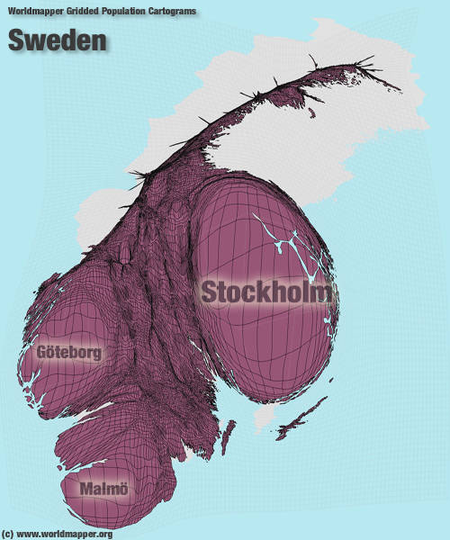
Sweden

The United States:
Central America:
Pakistan:
India
Taiwan
Sweden
Title: Re: anamorphosis maps
Post by: scarface on September 04, 2015, 10:51 PM
Post by: scarface on September 04, 2015, 10:51 PM
Today, I'm adding a new population density map, the one of Lebanon.

One third of the population is concentrated in the suburb of Beirut, while the East is more sparsely populated, because it is mountainous.
I'm taking this opportunity to give you a few comments about Lebanon which is a beautiful country, as we can see on these photos.
Beirut:


One third of the population is concentrated in the suburb of Beirut, while the East is more sparsely populated, because it is mountainous.
I'm taking this opportunity to give you a few comments about Lebanon which is a beautiful country, as we can see on these photos.
Beirut:
Title: Re: anamorphosis maps
Post by: scarface on December 05, 2016, 09:57 PM
Post by: scarface on December 05, 2016, 09:57 PM
I know that the users of the forum are particularly interested in these maps. That's why tonight I'm adding another cartogram.
Top Export by Revenue in Middle East Economies

Top Export by Revenue in Middle East Economies
Title: Re: anamorphosis maps
Post by: humbert on December 07, 2016, 03:23 AM
Post by: humbert on December 07, 2016, 03:23 AM
Regarding the map of the Middle East, what difference is there between Oil, Crude Oil and Petroleum? Is it that some countries refine the oil they dig out of the ground before selling it?
Title: Re: anamorphosis maps
Post by: scarface on December 13, 2021, 08:57 PM
Post by: scarface on December 13, 2021, 08:57 PM
Note that a few cartograms were added in the first message.
Title: Re: anamorphosis maps
Post by: scarface on May 12, 2022, 12:50 AM
Post by: scarface on May 12, 2022, 12:50 AM
Note that I added new maps in the first message of this topic.
I will post a new economic cartogram with explanations soon
I will post a new economic cartogram with explanations soon
Title: Re: anamorphosis maps
Post by: scarface on November 03, 2022, 07:12 AM
Post by: scarface on November 03, 2022, 07:12 AM
Maybe some of you have looked at the maps of this topic. It's always interesting to see and analyse some population maps.
Tonight I'm going to show you another map. And I'm going to talk about Seine-et-Marne. You have probably never heard of it. Is it a town of Texas? Is it a region of India?
Actually, Seine-et-Marne is a department in the Île-de-France region. Named after the rivers Seine and Marne, it is the region's largest department with an area of 5,915 square kilometres. It roughly covers its eastern half. Seine-et-Marne hosts a Disney theme park, known as Disneyland Paris, in Chessy.
Since it is in the Paris region, you probably think that it is very populated. While the west of the department is densely populated, as it's part of the Paris conurbation, it's not the case for the rest of the department: it is the least populated of the departments in Ile de France despite covering almost half the region's surface area. It boasts extensive agricultural land and a rich natural and built heritage, including the Fontainebleau forest.
If you are looking at the map below, you can see the Seine-et-Marne department East of the black line. Roughly 85% percent of the population of the Ile de France region is concentrated in the red rectangle.
Title: Re: anamorphosis maps
Post by: scarface on December 06, 2022, 01:38 AM
Post by: scarface on December 06, 2022, 01:38 AM
Tonight, I'm going to show you more maps.
If you like geography and if you have some maps to show, don't hesitate to post them on the forum.
Here is a map showing the density population of Indonesia.
Indonesia is a country located off the coast of mainland Southeast Asia in the Indian and Pacific oceans. It is an archipelago that lies across the Equator.

As you can see on this maps, the island of Java is the most densely populated island of the Archipelago.
Its islands can be grouped into the Greater Sunda Islands of Sumatra (Sumatera), Java (Jawa), the southern extent of Borneo (Kalimantan), and Celebes (Sulawesi); the Lesser Sunda Islands (Nusa Tenggara) of Bali and a chain of islands that runs eastward through Timor; the Moluccas (Maluku) between Celebes and the island of New Guinea; and the western extent of New Guinea (generally known as Papua). The capital, Jakarta, is located near the northwestern coast of Java.
The name Indonesia probably reminds you of India, and you might think that this region belongs to India. Actually it's not the case, but the name Indonesia is thought to derive from India indeed, with the Greek indos, meaning "India," and nesos, meaning "island.
Here you can see 2 maps: on the left, the standard map of Australia, and on the right, an anamorphic map of Australia, where territories are resized according to their population.

As you can see on this map, Western Australia and the Northern territory are less populated than the south-East of the country.
Maher must be wondering if the West Bank is more densely populated than Australia's Northern territory. And it's indeed the case. While the Northern territory is 242 times bigger than the West Bank, it is 13 times less populated. The reason is pretty simple: this territory is very arid. However, it is home to the infamous perentie lizard, that you have discovered in the best clips.
Below you can find a density map of Pakistan. You certainly heard of this country lately since it hit the headlines due to torrential monsoon rains that triggered the most severe flooding in Pakistan in recent history. Sindh has been the province worst affected by the floods while PunJab and the north of the country received little damage.

On this map you can see that Punjab is very densely populated thanks to its fertile arable land. Karachi and Lahore are the largest towns. In the west of the country, Balochistan is the largest region, but it's the least densely populated. It covers 40% of the country's land area, but accounts for less than 10% of its population. In a country as populated as Pakistan, Balochistan has a population on par with that of the Paris region, despite being 30 times bigger.
If you like geography and if you have some maps to show, don't hesitate to post them on the forum.
Here is a map showing the density population of Indonesia.
Indonesia is a country located off the coast of mainland Southeast Asia in the Indian and Pacific oceans. It is an archipelago that lies across the Equator.
As you can see on this maps, the island of Java is the most densely populated island of the Archipelago.
Its islands can be grouped into the Greater Sunda Islands of Sumatra (Sumatera), Java (Jawa), the southern extent of Borneo (Kalimantan), and Celebes (Sulawesi); the Lesser Sunda Islands (Nusa Tenggara) of Bali and a chain of islands that runs eastward through Timor; the Moluccas (Maluku) between Celebes and the island of New Guinea; and the western extent of New Guinea (generally known as Papua). The capital, Jakarta, is located near the northwestern coast of Java.
The name Indonesia probably reminds you of India, and you might think that this region belongs to India. Actually it's not the case, but the name Indonesia is thought to derive from India indeed, with the Greek indos, meaning "India," and nesos, meaning "island.
Here you can see 2 maps: on the left, the standard map of Australia, and on the right, an anamorphic map of Australia, where territories are resized according to their population.
As you can see on this map, Western Australia and the Northern territory are less populated than the south-East of the country.
Maher must be wondering if the West Bank is more densely populated than Australia's Northern territory. And it's indeed the case. While the Northern territory is 242 times bigger than the West Bank, it is 13 times less populated. The reason is pretty simple: this territory is very arid. However, it is home to the infamous perentie lizard, that you have discovered in the best clips.
Below you can find a density map of Pakistan. You certainly heard of this country lately since it hit the headlines due to torrential monsoon rains that triggered the most severe flooding in Pakistan in recent history. Sindh has been the province worst affected by the floods while PunJab and the north of the country received little damage.
On this map you can see that Punjab is very densely populated thanks to its fertile arable land. Karachi and Lahore are the largest towns. In the west of the country, Balochistan is the largest region, but it's the least densely populated. It covers 40% of the country's land area, but accounts for less than 10% of its population. In a country as populated as Pakistan, Balochistan has a population on par with that of the Paris region, despite being 30 times bigger.
Title: Re: anamorphosis maps
Post by: scarface on December 15, 2022, 01:52 AM
Post by: scarface on December 15, 2022, 01:52 AM
Tonight, I'm posting a few new maps on the forum.
And I'm going to explain the concept of macrocephaly.
In medicine, macrocephaly is a condition in which the head is abnormally large therefore I guess Humbert and shadow.97 may be wondering why I'm talking about a disease. Actually, this term has another meaning. In geography, it refers to the excessive concentration of population and development in a single centre, to the detriment of other areas.
In those countries, it seems the biggest urban area is much bigger than the second one. We can speak of macrocephaly.


In Italy, you can see that the size of the urban areas of Milan, Rome and Naples is pretty similar, the concept of macrocephaly can't be applied here.

In Australia, it seems there is pretty much nothing besides 5 big urban areas.

And I'm going to explain the concept of macrocephaly.
In medicine, macrocephaly is a condition in which the head is abnormally large therefore I guess Humbert and shadow.97 may be wondering why I'm talking about a disease. Actually, this term has another meaning. In geography, it refers to the excessive concentration of population and development in a single centre, to the detriment of other areas.
In those countries, it seems the biggest urban area is much bigger than the second one. We can speak of macrocephaly.
In Italy, you can see that the size of the urban areas of Milan, Rome and Naples is pretty similar, the concept of macrocephaly can't be applied here.
In Australia, it seems there is pretty much nothing besides 5 big urban areas.